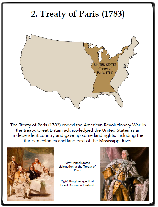
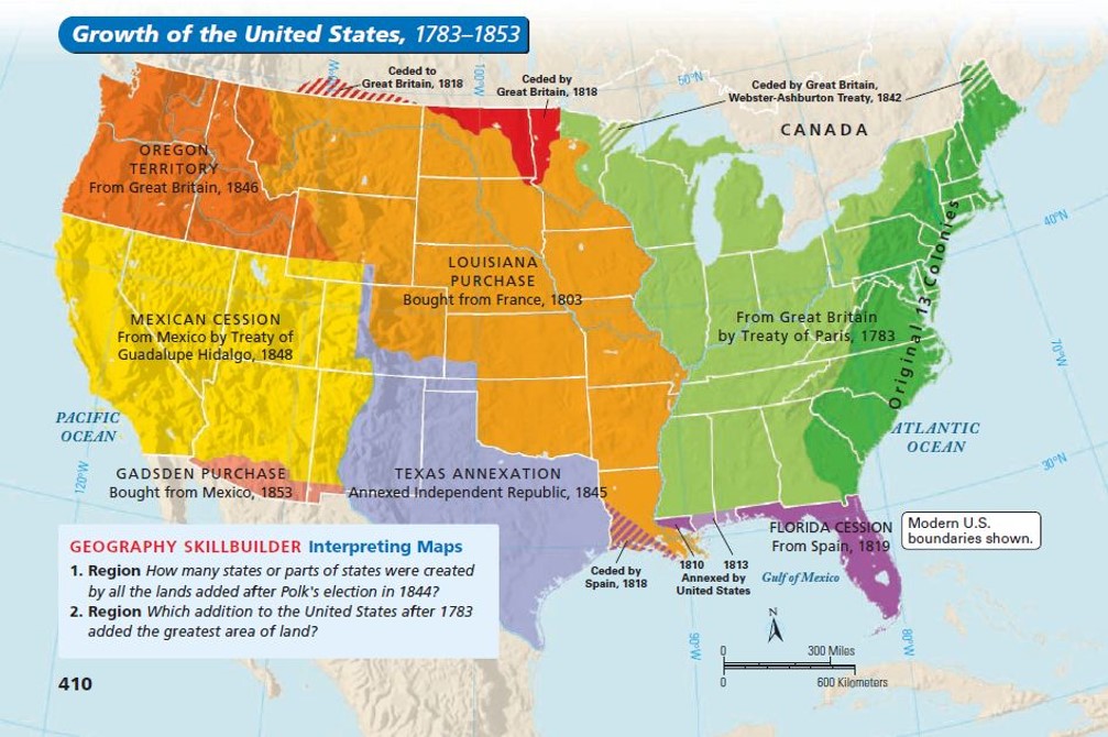
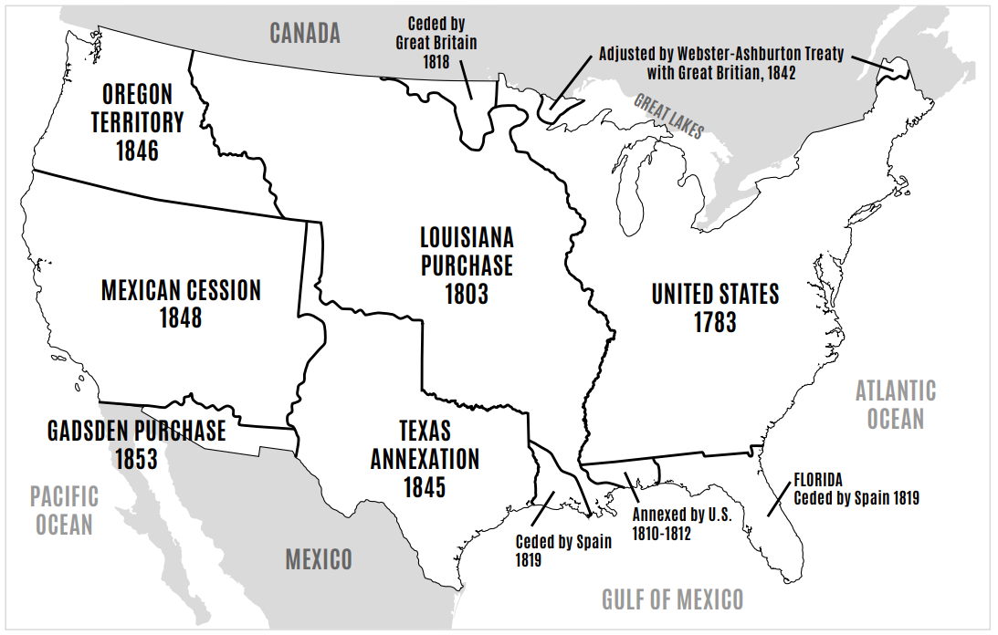
Back to Unit 5 home
Unit 5 · Visual Study

Maps & Territory

How the United States grew, in order. Each entry shows the lands added (or taken), why it mattered, and which content standard it belongs to. Use this page to picture westward expansion as a sequence — not just a list of names.

Std 1 · SlateStd 2 · NavyStd 3 · ForestStd 4 · GoldStd 5 · Maroon
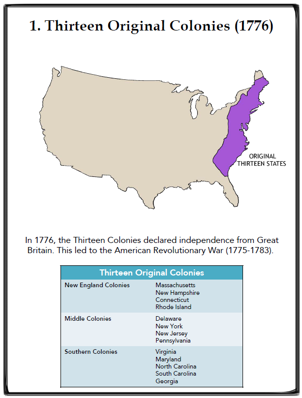
  1. 1. 13 Original Colonies

    The starting line. After the Revolution, the United States was a thin strip of thirteen colonies hugging the Atlantic coast — bordered by British Canada to the north, Spanish Florida to the south, and the Mississippi River far to the west.

    • New England, Middle, and Southern colonies along the Atlantic.
    • No territory yet beyond the Appalachian Mountains was officially American.
    Map of the 13 original American colonies along the Atlantic coast.
    The thirteen colonies that became the first United States.
  2. 2. Treaty of Paris — Additional Lands

    The Treaty of Paris ended the Revolution and gave the United States a huge stretch of land between the Appalachians and the Mississippi River. The U.S. instantly almost doubled in size before any westward expansion even began.

    • New western boundary: the Mississippi River.
    • Set the stage for the conflicts and compromises that came with growth.
    Map showing the additional lands gained by the United States from the 1783 Treaty of Paris.
    Lands added by the 1783 Treaty of Paris between the Appalachians and the Mississippi.
  3. 3. Louisiana Purchase

    President Jefferson bought roughly 828,000 square miles from France for about $15 million — around 3 cents an acre. The deal doubled the size of the United States and gave Americans control of the Mississippi River and the port of New Orleans.

    • Sold by Napoleon, who needed money for European wars.
    • Lewis and Clark were sent to explore the new territory.
    • All or part of 15 future states came from this single purchase.
    Infographic explaining the Louisiana Purchase: who, what, when, where, and cost.
    The Louisiana Purchase at a glance.
    Map of the Louisiana Purchase showing the modern U.S. states carved from the territory.
    Modern states formed from Louisiana Purchase land.
  4. 4. Land Ceded by Britain (Treaty of 1818)

    After the War of 1812, the U.S. and Britain agreed on a clean northern border at the 49th parallel from the Lake of the Woods to the Rocky Mountains. They also agreed to jointly occupy the Oregon Country for the time being.

    • Confirmed the 49th parallel as part of the U.S.–Canada border.
    • Set up the Oregon question that would have to be settled later.
    Map showing the land along the northern border ceded by Britain in the Treaty of 1818.
    The 1818 northern boundary fix along the 49th parallel.
  5. 5. Florida Cession (Adams-Onís Treaty)

    Spain ceded Florida to the United States and gave up its claims to the Pacific Northwest in exchange for $5 million in damage claims. The deal also drew a clear southwestern boundary between the U.S. and New Spain.

    • Negotiated by Secretary of State John Quincy Adams.
    • Cleaned up Spanish claims in the southeast and far west.
    Map of the 1819 Florida Cession showing the territory transferred from Spain to the United States.
    Florida joins the United States through the Adams-Onís Treaty.
  6. 6. Native American Removal

    The Indian Removal Act (1830) forced tens of thousands of Cherokee, Creek, Choctaw, Chickasaw, and Seminole people from their homelands in the Southeast onto land west of the Mississippi River. The forced march that followed became known as the Trail of Tears.

    • About 4,000 Cherokee died on the Trail of Tears (1838–39).
    • Removal cleared eastern land for white settlers and cotton plantations.
    Map showing routes of forced Native American removal from the Southeast to Indian Territory in present-day Oklahoma.
    Forced removal routes from the Southeast to Indian Territory.
  7. 7. Oregon Country & the Oregon Trail

    In the 1840s, thousands of American settlers loaded covered wagons and followed the 2,000-mile Oregon Trail from Missouri to the Willamette Valley. Drawn by free farmland and the idea of Manifest Destiny, they helped pull Oregon firmly into the American orbit.

    • Trail stretched from Independence, Missouri to Oregon City.
    • Took 4–6 months by wagon — disease and weather were the biggest dangers.
    Title slide introducing the Oregon Country and the Oregon Trail.
    Why settlers headed to Oregon.
    Map of the Oregon Trail from Missouri to the Pacific Northwest.
    The 2,000-mile route west.
  8. 8. Texas Annexation

    After winning independence from Mexico in 1836, the Republic of Texas asked to join the United States. Congress finally agreed in 1845, making Texas the 28th state — and infuriating Mexico, which still considered Texas its own territory.

    • Annexation made Texas the 28th state.
    • Pushed the U.S. and Mexico toward war.
    Title slide showing the 1845 annexation of the Republic of Texas into the United States.
    The Republic of Texas becomes the 28th state.
  9. 9. Oregon Treaty

    After years of joint occupation and the campaign cry of “54°40′ or Fight,” the U.S. and Britain peacefully split the Oregon Country at the 49th parallel — the same line used farther east. The American share later became Oregon, Washington, and Idaho.

    • Border set at the 49th parallel rather than 54°40′ N.
    • Avoided a second war with Britain over the Pacific Northwest.
    Map of the Oregon Country showing the U.S. and British shares after the 1846 Oregon Treaty.
    Oregon Country split at the 49th parallel.
  10. 10. Texas Border Dispute & the Mexican-American War

    The U.S. claimed the Rio Grande as the southern border of Texas; Mexico said the border was the Nueces River, much farther north. President Polk sent troops into the disputed strip, fighting broke out, and the Mexican-American War began.

    • Disputed strip of land between the Nueces and Rio Grande Rivers.
    • War ended with the Treaty of Guadalupe Hidalgo in 1848.
    Map of the disputed border between the Nueces River and the Rio Grande.
    The disputed border that triggered the war.
  11. 11. Mexican Cession

    The Treaty of Guadalupe Hidalgo ended the war and forced Mexico to give up roughly 525,000 square miles — about half of its land. The U.S. paid $15 million. The cession included present-day California, Nevada, Utah, and parts of Arizona, New Mexico, Colorado, and Wyoming.

    • Pushed the U.S. all the way to the Pacific.
    • Reopened the question of slavery in new territories.
    Title slide showing the lands acquired in the 1848 Mexican Cession.
    Mexican Cession lands transferred in 1848.
  12. 12. Gadsden Purchase

    The U.S. paid Mexico $10 million for a thin strip of land along the southern edges of present-day Arizona and New Mexico. The land was wanted for a southern transcontinental railroad route. This was the final piece needed to complete the lower 48 states.

    • Bought to enable a southern railroad route.
    • Finalized the modern continental U.S. border with Mexico.
    Title slide showing the location of the 1853 Gadsden Purchase along the U.S.–Mexico border.
    The last piece of the continental U.S.
  13. 13. Transcontinental Railroad

    The Union Pacific built west from Omaha, Nebraska while the Central Pacific built east from Sacramento, California. Their tracks met at Promontory Summit, Utah on May 10, 1869, finally linking the East Coast to the Pacific by rail.

    • Cut a six-month wagon journey down to about a week.
    • Built largely by Irish, Chinese, and formerly enslaved laborers.
    • Accelerated settlement, trade, and the displacement of Plains tribes.
    Photograph and map of the completed Transcontinental Railroad route across the United States.
    The country, finally linked coast to coast.
    Document and detail map about the building of the Transcontinental Railroad.
    The story behind the rails.
Putting It All Together

Big-picture maps

Once you can recognize each acquisition on its own, try seeing them all at once. The blank map at the bottom is a quick self-quiz — cover the answers and label each region from memory.

Color-coded map showing the growth of the United States by territorial acquisition.
Growth of the United States — every acquisition on a single map.
Black-and-white reference map labeling each major territorial acquisition of westward expansion.
Black-and-white reference map with every acquisition labeled.
Blank black-and-white outline map of westward expansion territories for self-quizzing.
Blank version — print or screenshot it and try labeling each acquisition from memory.
Continue to the unit timeline